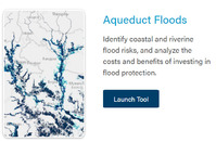
Flood mapping is crucial to flood risk management and risk reduction. Flood mapping helps minimise the loss and damage caused by floods. If you know what areas have high exposure to flood risk you can choose not to build important infrastructure, like hospitals, there. Flood maps also play an important role in risk communication, if people know they live in an area with flood risk they are more likely to seek information on how to protect themselves, and take alerts and warning seriously.
Different types of maps
A flood hazard map is one that provides information about the hazard. How extensive and deep are floods in an area likely to be under different scenarios? Flood hazard maps could show whether an area is likely to become flooded, what type of floods are most likely, and how bad the flood is likely to be.
A flood risk map needs to show who or what (people, businesses, infrastructure etc.) is at risk of flooding. Floods are a natural phenomenon which only become a problem when people and assets are exposed to it.
Participatory mapping refers to processes where individuals and communities are involved in the mapping processes, their experience and knowledge of the local area and historical flooding is used to create maps.
How are flood maps useful?
Flood maps or flood mapping exercises are vital for a range of activities carried out my public, private, and third-sector actors including: to establish and enforce zoning, land use and building standards, when planning and building infrastructure and transportation networks, for flood warning, evacuation and emergency management and planning.
For communities and individuals flood maps are useful for understanding the risk they face and prepare accordingly. Many governments have flood risk maps available online, some update risk levels regularly. Use a search engine to find maps available for your area.
Flood mapping exercises carried out with or by communities can provide useful knowledge and for example identify safe evacuation routes, suitable locations for emergency shelters, and community members who are particularly vulnerable to flooding. In the resources below you can find a range of useful mapping exercises for understanding and mitigating community flood risk.